Quantifying Solar Permitting Risk with Large Language Models

Community and utility-scale solar developers must consider a variety of factors when identifying suitable areas for new projects. Interconnection and hosting capacity constraints, the environmental attributes of the land, and local zoning and permitting processes all impact project success rates. However, this last variable – permitting risk – can be particularly enigmatic. Local authorities having jurisdiction (AHJs), which can be townships, villages, municipalities, or counties, determine the zoning processes for their areas and often have very specific regulations delineating exactly how and where they would like solar development to proceed (or to not proceed) in the communities they represent. The data outlining these zoning regulations are usually unstructured and unstandardized across AHJs, making finding and organizing relevant information difficult and time consuming.
With the rise of Large Lange Models (LLMs), every industry with large quantities of textual data has been exploring new chat-based applications. However, many of these experiments have been running into a roadblock: niche problems such as parsing zoning legislation require domain-specific context and expertise. Chat applications may be helpful for lightly summarizing vast amounts of information in a digestible format but not necessarily thinking deeply about specific, difficult issues.
Still, there is a middle ground. If an LLM knows exactly what to look for, it can automatically read thousands of pages of PDF documents and extract valuable information pertaining to a specific problem, such as identifying areas with favorable paths to permitting. At Paces, we’ve begun structuring LLM prompts to reason through zoning legislation for hundreds of AHJs and rank development zones according to their solar permitting favorability, enabling developers to quickly determine which communities have the most favorable regulations for their type of development. Here’s how it works.
Assume we have identified a few plots of land in a township in upstate New York that look good from a geophysical and interconnection perspective; it’s flat, cleared land with good hosting capacity numbers from the utility. How do we know how the community might react to proposed projects on each plot? Perhaps they are in a waterfront revitalization area or a protected agricultural zone where solar projects of any kind are forbidden. On the other hand, they could be in an industrial development zone where all energy projects are encouraged and can be built after obtaining a simple special use permit. Without finding and reading through the legislation then cross referencing the documents with the zoning map, developers are in the dark about whether these sites are viable opportunities.
This is where an LLM can work for the developer. First, it needs to identify the specific term that the legislation uses to describe the type of project they want to build. So we create the following project description, in this case outlining the general requirements and purpose of a community solar project:
Us: "a 2-megawatt ground-mount or freestanding solar system that requires about 12 acres of land and sells power back to the electricity grid such that a majority of electricity produced is not consumed on site and it is used for commercial purposes”
With a thorough description of the project the developer would like to build, we next ask the LLM to pull all the information it can find about how the community categorizes and defines solar projects. Then, we ask it to compare each category to the rich project description and identify which fits best.
LLM: "Solar Farms: This category is the most applicable to your project. It refers to a solar energy system or collection of solar energy systems or area of land principally used to convert solar energy to electricity, with the primary purpose of supplying electricity to a utility grid for wholesale or retail. Your project description matches this definition as it is a ground-mounted system that sells power back to the electricity grid for commercial purposes. Therefore, based on the provided information and the definitions in the legislation, the category that best fits your proposed project is "Solar Farms". "
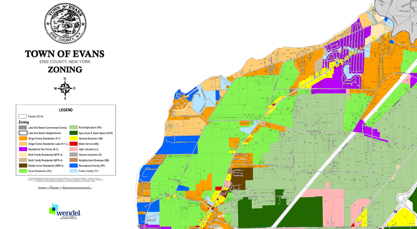
Now that we’ve identified the correct term the legislation uses for the type of solar project the developer wants to build, we can refer to it when checking the permitting status of each zoning district we’re interested in. Typical zoning maps come as shapefiles (if you’re lucky) or PDFs (which need to be georeferenced before specific plots of land can be linked to zones). For example, here is the zoning map for the Town of Evans in Erie county, New York:
After digitizing each AHJ’s zoning maps, we can match each plot of land to a zone code and description, such as Residential (R1), Light Industrial District (LI), etc. Then, for each zone, we tell the LLM to check whether the legislation decrees it is forbidden or allowed and under what conditions. Here is how the model would evaluate the Light Industrial District in a sample AHJ:
LLM: "The legislation specifies that Solar Farms are allowed only in the Light Industrial District (LI) within the Town, subject to the issuance of site plan approval and a special use permit. Solar Farms are explicitly prohibited in the Commercial District (CD), Professional and Commercial Office District (PCO), Planned Economic District (P-E), and One-Family Residential Districts (R-1, R-2). Given this information, Solar Farms in the Light Industrial District (LI) are allowed with a "special use" permit."
In this case, the legislation clearly outlines which zones allow and prohibit solar farms, making it relatively easy for the model. However, perhaps the legislation is written more ambiguously and doesn’t explicitly mention every single zone we are interested in. In this case, we need to help the model make inferences to arrive at the correct answer, as a developer would. For example, if we identify another zone called Residential Business (RB) and the text says “Solar Farms are prohibited in all zones except Agricultural (A)”, then we want the LLM to assume that projects are forbidden in RB even though it doesn’t explicitly mention any other zones besides A.
LLM: "According to the legislation, Solar Farms and Solar Power Plants are only permitted in the Agricultural (A) and AR-40 Districts. The legislation does not mention neighborhood residential business with zone code NR-BD specifically. Therefore, based on the instructions provided, we can assume that Solar Farms and Solar Power Plants are "forbidden" in the NR-BD zone."
By outlining explicit directions in domain-specific prompts, we can direct the LLM to both retrieve the right information and reason through the walls of legalese. And if the developer can send the model to investigate the permitting status for thousands of plots across hundreds of different local communities, then they can pull a lot of the messy, qualitative, and time consuming research up to their first level of their analysis and prioritize the most promising sites.
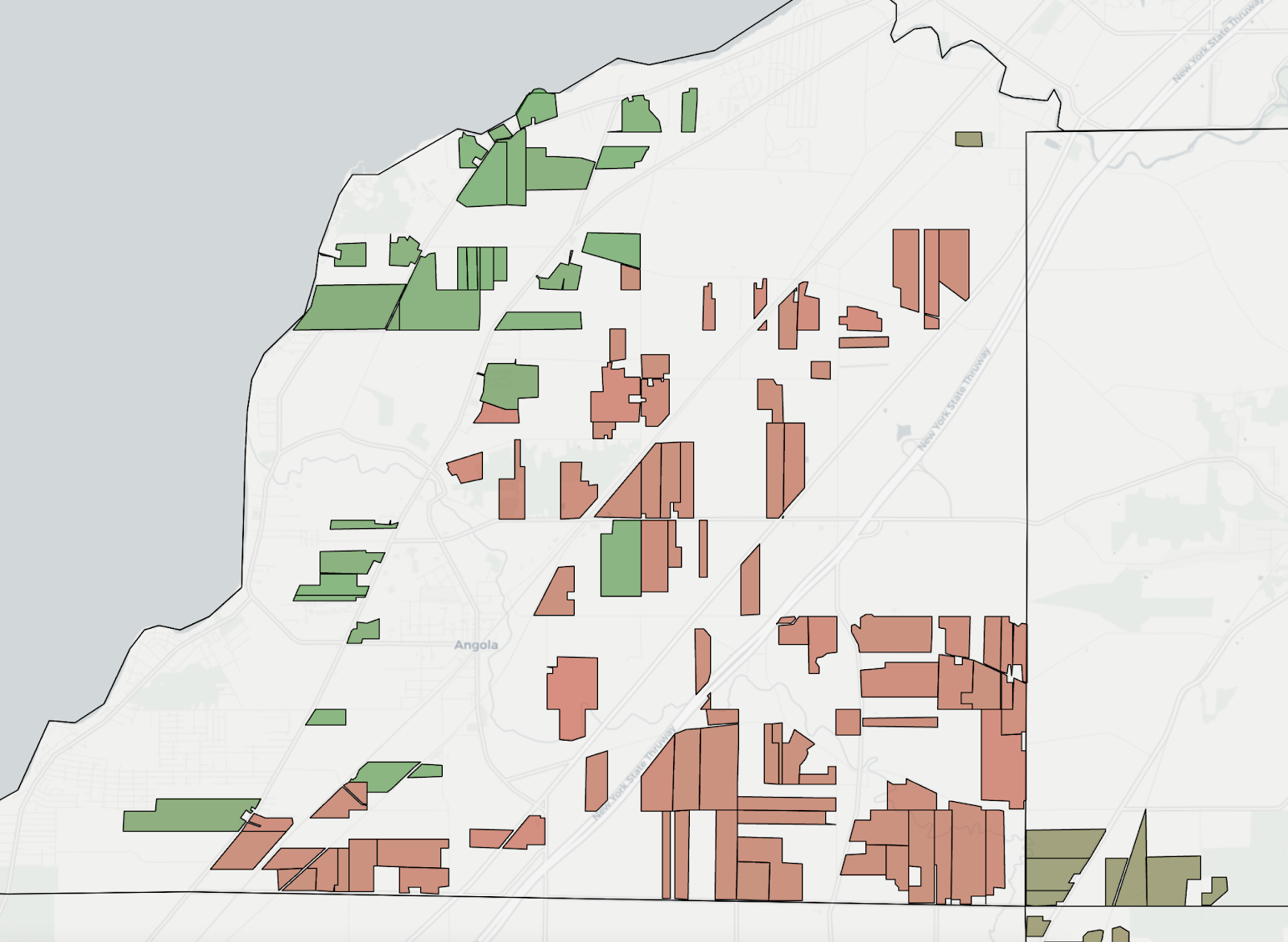
The final step is translating this knowledge into an overall quantitative score so developers can sort origination opportunities. In the image shown below, plots with unfavorable permitting legislation are shown in red and plots with favorable legislation are in green:
The energy industry is overflowing with text. Legislation, interconnection studies, net metering requirements, market reports, and other essentials of the development process are all stored in pages and pages of PDFs and word documents. This data environment is an area where LLM applications can naturally excel if leveraged properly. Thoughtful prompting and system design can maximize the advantages of both humans and machine learning models, enabling project developers to sift through massive amounts of unstructured, messy data at scale.
Thanks for reading! If you’re interested in learning more about our approach, please reach out to team@paces.com.
Sign up for emails
Find the right sites faster, assess feasibility with world class data, and track progress across your entire project pipeline with software built to compress your workflow.